DJI Phantom 4 Multispectral RTK with Shield License
Plant Intelligence for Targeted Action
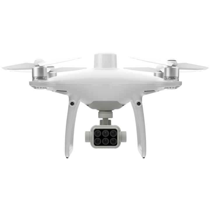
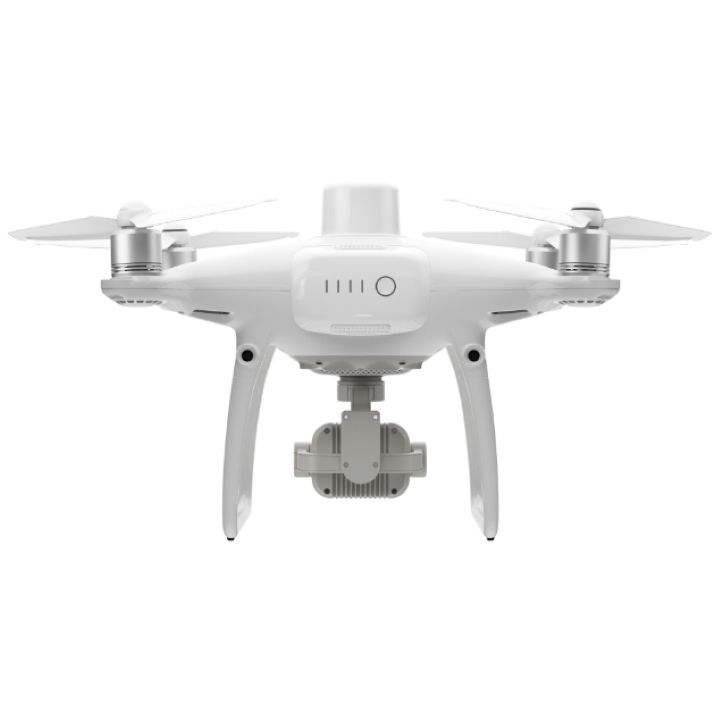
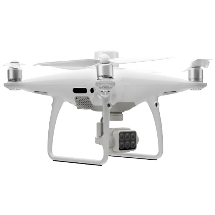
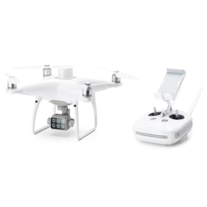
Gather precise plant-level data using the P4 Multispectral – a high-precision drone with a seamlessly integrated multispectral imaging system built for agriculture missions, environmental monitoring, and more.
Farm to Figures
Gain Immediate Insights into Plant Health
The P4 Multispectral consolidates the process of capturing data that gives insight into crop health and vegetation management. DJI has created this platform with the same powerful performance standards that DJI is known for, including 27 minutes max flight time and up to 7 km1 transmission range with the OcuSync system.

Aircraft
| Takeoff Weight | 1487 g |
| Diagonal Distance (Propellers Excluded) | 350 mm |
| Max Service Ceiling Above Sea Level | 6000 m |
| Max Ascent Speed | 6 m/s (automatic flight); 5 m/s (manual control) |
| Max Descent Speed | 3 m/s |
| Max Speed | 31 mph (50 kph) (P-mode); 36 mph (58 kph) (A-mode) |
| Max Flight Time | Approx. 27 minutes |
| Operating Temperature | 0° to 40° C (32° to 104° F) |
| Operating Frequency | 2.4000 GHz to 2.4835 GHz (Europe, Japan, Korea) 5.725 GHz to 5.850 GHz (Other countries/regions)[1] |
| Transmission Power (EIRP) | 2.4 GHz: < 20 dBm (CE / MIC / KCC) 5.8 GHz: < 26 dBm (FCC / SRRC / NCC) |
| Hover Accuracy Range | RTK enabled and functioning properly: Vertical: ± 0.1 m; Horizontal: ± 0.1 m RTK disabled: Vertical: ± 0.1 m (with vision positioning); ± 0.5 m (with GNSS positioning) Horizontal: ± 0.3 m (with vision positioning); ± 1.5 m (with GNSS positioning |
| Image Position Compensation | The relative positions of the centers of the six cameras’ CMOS and the phase center of the onboard D-RTK antenna have been calibrated and are recorded in the EXIF data of each image. |
GNSS
| Single-Frequency High-Sensitivity GNSS | GPS + BeiDou + Galileo[2] (Asia); GPS + GLONASS + Galileo[2] (other regions) |
| Multi-Frequency Multi-System High-Precision RTK GNSS | Frequency Used GPS: L1/L2; GLONASS: L1/L2; BeiDou: B1/B2; Galileo[2]: E1/E5 First-Fixed Time: < 50 s Positioning Accuracy: Vertical 1.5 cm + 1 ppm (RMS); Horizontal 1 cm + 1 ppm (RMS). 1 ppm indicates error with a 1 mm increase over 1 km of movement. Velocity Accuracy: 0.03 m/s |
Mapping Functions
| Ground Sample Distance (GSD) | (H/18.9) cm/pixel, H indicates the aircraft altitude relative to the area mapped (unit: m) |
| Rate of Data Collection | Max operating area of approx. 0.47 km2 for a single flight at an altitude of 180 m, i.e., GSD is approx. 9.52 cm/pixel |
Gimbal
| Controllable Range | Tilt: -90° to +30° |
Vision System
| Velocity Range | ≤ 31 mph (50 kph) at 6.6 ft (2 m) above ground with adequate lighting |
| Altitude Range | 0 - 33 ft (0 - 10 m) |
| Operating Range | 0 - 33 ft (0 - 10 m) |
| Obstacle Sensory Range | 2 - 98 ft (0.7 - 30 m) |
| Operating Environment | Surfaces with clear patterns and adequate lighting (> 15 lux) |
Camera
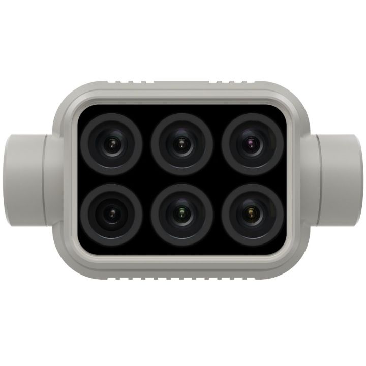
| Sensors | Six 1/2.9” CMOS, including one RGB sensor for visible light imaging and five monochrome sensors for multispectral imaging. Each Sensor: Effective pixels 2.08 MP (2.12 MP in total) |
| Filters | Blue (B): 450 nm ± 16 nm; Green (G): 560 nm ± 16 nm; Red (R): 650 nm ± 16 nm; Red edge (RE): 730 nm ± 16 nm; Near-infrared (NIR): 840 nm ± 26 nm |
| Lenses | FOV (Field of View): 62.7° Focal Length: 5.74 mm (35 mm format equivalent: 40 mm), autofocus set at ∞ Aperture: f/2.2 |
| RGB Sensor ISO Range | 200 - 800 |
| Monochrome Sensor Gain | 1 - 8x |
| Electronic Global Shutter | 1/100 - 1/20000 s (visible light imaging); 1/100 - 1/10000 s (multispectral imaging) |
| Max Image Size | 1600×1300 (4:3.25) |
| Photo Format | JPEG (visible light imaging) + TIFF (multispectral imaging) |
| Supported File Systems | FAT32 (£ 32 GB); exFAT (> 32 GB) |
| Supported SD Cards | microSD with a minimum write speed of 15 MB/s. Max Capacity: 128 GB. Class 10 or UHS-1 rating required |
| Operating Temperature | 0° to 40° C (32° to 104° F) |
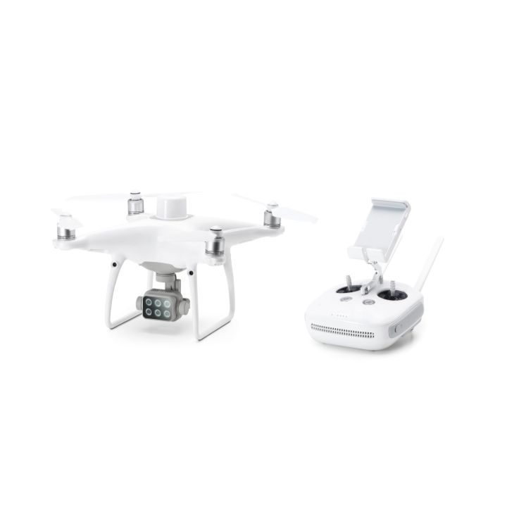
Remote Controller
| Operating Frequency | 2.4000 GHz to 2.4835 GHz (Europe, Japan, Korea) 5.725 GHz to 5.850 GHz (Other countries/regions)[1] |
| Transmission Power (EIRP) | 2.4 GHz: < 20 dBm (CE / MIC / KCC) 5.8 GHz: < 26 dBm (FCC / SRRC / NCC) |
| Max Transmission Distance | FCC / NCC: 4.3 mi (7 km) CE / MIC / KCC / SRRC: 3.1 mi (5 km)(Unobstructed, free of interference) |
| Built-in Battery | 6000 mAh LiPo 2S |
| Operating Current / Voltage | 1.2 A @ 7.4 V |
| Mobile Device Holder | Tablets and smartphones |
| Operating Temperature | 0° to 40° C (32° to 104° F) |
Intelligent Flight Battery (PH4-5870mAh-15.2V)
| Capacity | 5870 mAh |
| Voltage | 15.2 V |
| Battery Type | LiPo 4S |
| Energy | 89.2 Wh |
| Net Weight | 468 g |
| Operating Temperature | -10° to 40° C (14° to 104° F) |
| Charging Temperature | 5° to 40° C (41° to 104° F) |
| Max Charging Power | 160 W |
Intelligent Flight Battery Charging Hub (PHANTOM 4 CHARGING HUB)
| Voltage | 17.5 V |
| Operating Temperature | 5° to 40° C (41° to 104° F) |
AC Power Adapter (PH4C160)
| Voltage | 17.4 V |
| Rated Power | 160 W |
[1] To comply with local laws and regulations, this frequency is not available in some countries or regions.
[2] Support for Galileo is coming soon.
| Product Manuals | |
|---|---|
| DJI Phantom 4 Multispectral RTK with Shield License - Product Manual |
|
|
"Best prices guaranteed! We’ll match or beat any legitimate prices."
Read the CASA Drone regulations @ knowyourdrone.gov.au
Brand: DJI |
Code: DJIPH4MULTI
APN: 6958265197970 |
Supplier Code: CP.AG.00000208.01

Brand: DJI |
Code: DJIPH4MULTI
APN: 6958265197970 |
Supplier Code: CP.AG.00000208.01
At a glance
"Best prices guaranteed! We’ll match or beat any legitimate prices."
Read the CASA Drone regulations @ knowyourdrone.gov.au
See Beneath the SurfaceAgriculture imagery collection is now simpler and more efficient than ever before with a built-in stabilized imaging system that collects comprehensive data sets right out of the box. Access information collected by 1 RGB camera and a multispectral camera array with 5 cameras covering Blue, Green, Red, Red Edge, and Near Infrared bands – all at 2 MP with global shutter, on a 3-axis stabilized gimbal. |
 |
 |
Integrated Spectral Sunlight Sensor for
|
View Both RGB and NDVI FeedsSimply having aerial imagery is not enough for ag professionals who want to know more. Switch between a preliminary Normalized Difference Vegetation Index (NDVI) analysis and the live RGB feed to immediately visualize where attention is needed, so targeted treatment decisions can be made quickly. |
 |
 |
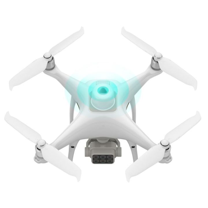
Centimeter-level PrecisionGet real-time, accurate positioning data on images captured by all six cameras with DJI’s TimeSync system, providing centimeter-level accurate measurements. The TimeSync system continually aligns the flight controller, RGB and NB cameras, and RTK module, fixing the positioning data to the center of the CMOS and ensuring each photo uses the most accurate metadata. All cameras go through a rigorous calibration process where radial and tangential lens distortions are measured. The distortion parameters gathered are saved into each image’s metadata, letting post-processing software adjust uniquely for every user.
|
D-RTK 2 Mobile Station and NTRIP CompatibilityEnhance the accuracy of RTK positioning without internet connection by connecting the P4 Multispectral to the D-RTK 2 High Precision GNSS Mobile Station and NTRIP (Network Transport of RTCM via Internet Protocol)2, or store the satellite observation data to be used for Post Processed Kinematics (PPK). |
 |
 |
Plan FlightsPlan flights, execute automated missions, and manage flight data using GS PRO – DJI’s leading flight planning iOS app. |
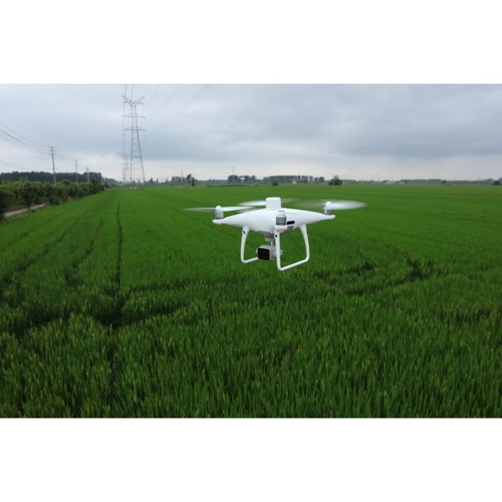
Capture DataCollect multispectral images efficiently across a large area using the P4 Multispectral and gain an overview of problem areas. |
 |
 |
Analyze DataEasily access and process aerial data by applying plant-specific metrics and parameters to acquire the desired results on plant health. |
Act on DataImplement targeted treatments on areas that need attention based on |
 |


